|
|
|
|
Cities and TownsAfghanistan is predominantly rural, but the cities and towns play an important part in the cultural and commercial life of the country, for exempel:
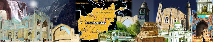
Kabul,the capital and largest city, is in northeastern Afghanistan, near the Pakistan border. It lies at an altitude of 6,000 feet (1,829 meters) along both banks of the Kabul River. For centuries important towns have been situated in this locality, where the trade routes leading southward from central Asia across the Hindu Kush converge with major east-west routes. In the 1800s, when the British and Russian empires tried to exploit the strategic value of the country, Kabul was twice taken by British forces. The city has piped water and electricity, and most of its streets are paved. Although the site is attractive, with mountains on every horizon, points of interest are comparatively few. Since the city is the seat of the government, there are substantial modern buildings that house the ministries, banks, and schools, including Kabul University. Just southwest of the city are the garden and tomb of Babur, and farther in this direction is a wooded area in which the Kabul Museum is located. To the east is the mausoleum of Nadir Shah. Some hours by road to the northeast of Kabul is the spectacular valley of Bamiyan, where there are two huge rockcut Buddhas made before the 600s A.D.
Kandahar,capital of Kandahar province in the south, is Afghanistan's second-largest city. It is the rapidly growing center of a farming area. This area is irrigated by water impounded by the dams on the Helmand River and its tributary, the Arghandab. The dams, reservoirs, and canals already built or under construction will irrigate some 750,000 acres (303,525 hectares) of dry and unproductive land and will provide hydroelectric power for homes and industries. An international airport is located just east of Kandahar.
Herat,in eastern Afghanistan, is situated in the heart of the valley of the Hari Rud, an area that produces fruit and grain. The city has several important mosques and shrines of the Timurid period.
Jalalabad,on the highway between Kabul and Khyber Pass into Pakistan, enjoys a semitropical climate and is known for the citrus fruits cultivated in the surrounding area.
Mazar-i-Shariflies on a well-watered plain 13 miles (21 km) southeast of the Tajikistan. West of the city are the ruins of ancient Balkh. Situated in a region where vast flocks of sheep are raised, Mazar-i-Sharif is an important trading center for northern Afghanistan and for commerce with the former USSR. Its name, which means “noble tomb,” is derived from a group of faďence-covered buildings in the heart of the city. Afghans believe that this shrine contains the remains of 'Ali ibn-abi-Talib, son-in-law of the prophet Mohammed and the greatest saint of the Shiite sect of Islam.
Ghazni,75 miles (121 km) southwest of the capital, is an important commercial
city in an area noted for its fine fruits. The city contains the ruins of the great 11th
century capital of Mahmud of Ghazni. His mausoleum and two towering minarets still stand. The industrial centers of Baghlan, with a beet-sugar refinery, and Pul-i-Khumri, with a large cotton-textile factory, are located north of the Hindu Kush... |
|